August 29, 2015

iphone 6+ The old, charming plaza in Peyriac de Mer, South of France


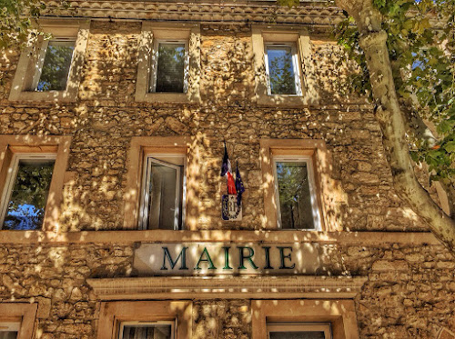
As going direct back to Medieval times. Entering this old Plaza, sitting down for a soft drink at the small bar, facing the old church from 1450 and in the building at left the Majors office.

Stretching out your arms you can almost touch each of the walls. A super place to just sit and enjoy such a place rich of old traditions.

Afterwards you can eventually take a walk along the old salt lakes or dream of the time 1000 years ago when the Mediterrannian sea level was higher and Periac was just a small harbour under the big Narbonne county.

EXIF
2015:08:25 15:35:07
Apple iPhone 6 Plus
Focal Length:
29mm (35mm eq.)
Aperture: f/2.2
Exposure: 1/807s
Ev: 11.9
ISO equiv: 32


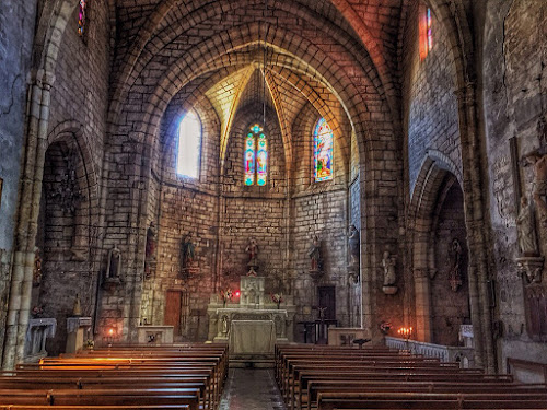
Interior of the old church from 1450 build over the burial place and sarcophage of St. Paul of whom there is at least 2 myths - one that he lived here in 250 AD and the more exciting that he lived here in 50 AD.
 
The village is just a few kilometers form the old Roman road Via dolomita traversing from Rome to Gilbraltar. And also close to Narbonne - already in ancient times a big city and central place for Roman legions travelling between Rome and Spain.
 
 
Also the Mairie the Major is situated around the smal, intimate, plaza in the charming old village Peyriac de Mer in the South of France.

August 26, 2015

iphone 6+ Art in nature by the salt lake in Peyriac de mer in Sud du France


For over 300 years there was an active industry in those salt lakes close to the small village Peyriac de mer in Languedoc-Rousillon.

Today there are several paths leading over and around those saltlakes, also traversing some low hills in the beautiful landscape.

<b>EXIF</b>
2015:08:25 14:20:24
Apple iPhone 6 Plus
Focal Length:
29mm (35mm eq.)
Aperture: f/2.2
Exposure: 1/1799s
Ev: 13.1
ISO equiv: 32


Another view along the shores of the saltlakes near Peyriac de mer
 
 
The madam enjoys her walk around the saltlakes and hills near the fine small village Peyriac de mer in South of France
 
 
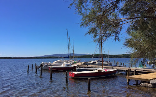
The small marina just outside the village

August 24, 2015

Iphone6+ Catalan boats in harbour, Collioure, Sud du France

 
Catalan boats in Colliore under the St. Vincent festival in August. In the back the old church where the bell tower was a lighthouse in ancient times.

EXIF
2015:08:17 13:05:43
Apple iPhone 6 Plus
Focal Length:
29mm (35mm eq.)
Aperture: f/2.2
Exposure: 1/1980s
Ev: 13.2
ISO equiv: 32
 
 
Another version of the fine, old, Catalan boats
 

August 22, 2015

Walking the Chemins Littorale in Port-Vendres, Sud du France


In these Days of August we are again back to our place by the foot of the Pyrenees just by the border of France and Spain.

Here traversing the hills by the port to the det harbour of Port-Vendres.

EXIF
2015:08:14 12:42:15
Apple iPhone 6 Plus
Focal Length:
29mm (35mm eq.)
Aperture: f/2.2
Exposure: 1/3049s
Ev: 13.8
ISO equiv: 32

August 20, 2015

Coast of Norway - Crossing the Polar / Arctic circle


On a little island along the coast of Nordland we are passing the little symbol for crossing the Polar Circle.

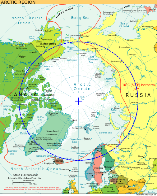
Illustration of the Arctic Circle from WIKI
Looking to the West we can see a car ferrry on it's way to the distant Træna islands out in the sea.

August 18, 2015

Svolvær in Lofoten, Norway


The daily arrival in Svolvær of the coastal express is always attracting people living in or visiting this "Capitol" of Lofoten.


The modern, central, Svolvær.

WIKI:
The first town formation known in North Norway, Vågar, was situated around the narrow, natural harbor near Kabelvåg, just west of Svolvær. Vågar is mentioned in the book Heimskringla, and might have been established as early as the year 800.

One of the first churches in North Norway was most likely built here, approximately 900 years ago. The great cod fisheries in winter has always been the most important economical foundation for the town, but fish farming (salmon) is also important in Vågan, as is Secora and Lofotkraft.

Town status:
Svolvær was an important fishing village for a long time, and because of this, it was given town status in 1918. On 1 July 1918, the new town of Svolvær was separated from the municipality of Vågan to become its own municipality. Initially, the new municipality had 2429 residents. Today app. 5000.


Another street capture from Svolvær. 
Regard the horns of the cliff Svolværgeita in the upper right part of the photo.

 
The madam enjoys the dinner onboard MS Nordkapp after a fine day at sea.

August 14, 2015

Coast of Norway: Svolvær / Svolvar incl. jumping Svolværgeita / the Svolvar goat.


Sailing in to Svolvær, the most central town and harbour in Lofoten we are met by the statue: "Fishermans wife" (made by Per Ung). In this version head decorated by a bypassing seagull.
 
 
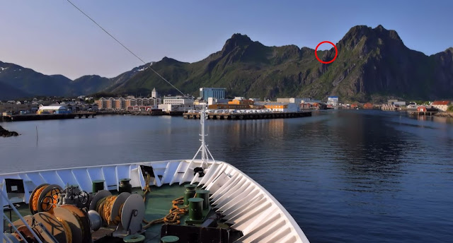
I was at the bridge in front of the boat capturing this fine town in Lofoten - also with the background low mountains. In the red circle there is a kind of cliff with 2 high cliff-walls at top called Svolværgeita - The Svolvær goat.
I could not see any details over there but did with a 2 minutes intervall 2 shots with my 150mm lens (equal to 300mm classic). Later I enlarged (by cropping) the photos and could see that I by a coincidence had captured a person jumping Svolværgeita. Look below for details:
 
 
Maybe not the best of quality - but what to expect with a small lens some 1-2 km away shooting from the bridge of my ship.
 
At left you see a person on the left horn of Svolværgeita preparing to jump. To the right, 2 minutes later the climber have made the jump and landed at the right horn of this "goat".
 
Belive it or not - a quite popular event that you can even buy as a tourist - where you led by a professional guide is offered to do this jump by yourself. That is after traversing and climbing with rope some very airy places along the way...

August 12, 2015

Coast of Norway: Sailing along landscapes in Lofoten


A fishing sjark / cutter is going home along the coast of Lofoten.


Typical Lofoten landscape with the low mountains shooting up from the sea


Having fun with water scooters in Lofoten


Taking the girl out for a ride


More fun outside the Lofoten nature

August 7, 2015

Trollfjorden in Raftesundet, Lofoten, Norway


One of the smallest but also one of the most wellknown fjords in Norway is the narrow Trollfjorden:

From WIKI: The Trollfjord (Trollfjorden) is a 2 km long sidearm of the Raftsund between the Norwegian archipelagos of Lofoten and Vesterålen.
With its narrow entrance and steep-sided mountains, Trollfjord cuts westwards from the Raftsundet strait. The name is derived from troll, a figure from Norse mythology.
The mouth of the Trollfjord where it joins the Raftsund is only 100 meters wide. The fjord widens to a maximum width of 800 meters. The mountains surrounding Trollfjord are between 600 to 1100 metres high. The Trollfjord is 72 metres at its deepest point.


The highlight of the day is looking opp to the mountains surrounding this little narrow fjord up in Lofoten.


Looking the other way - out of the fjord - where small boats are coming and going all the time this fine summer day.

  The madam enjoys the Trollfjord nature


After some delay in turning the ship in the end of the fjord we are steaming out of the fjord bypassed by some cabin cruiser.


Out of Trollfjord ready for our next stop: Svolvær / Svolvar in Lofoten

After visiting this very tiny fjord you may have a smile reading a general review of Norwegian fjords as presented at the review net page for MS Nordkapp at cruisecritic.com:

"Note that the word fjord in Norwegian has a meaning that's basically "bay", while in english it's more like "bay with steep cliffs". We heard one other passenger saying "his only regret regarding the cruise is that he didn't see any fjords". Ironic."

What a piece of argument but 100% in accordance with this question asked to a tour-guide some time ago: "When are you closing the fjords in the evening?"

Please: Should you ever visit our coast landscape and fjords - get some basic facts of what a fjord is in the countries where the word fjord has it origin:

The use of the word fjord in Norwegian, Danish and Swedish is more general than in English and in international scientific terminology. In Scandinavia, fjord is used for a narrow inlet of the sea in Norway, Denmark and western Sweden, but this is not its only application. In Norway and Iceland, the usage is closest to the Old Norse, with fjord used for both a firth and for a long, narrow inlet. /Ref. WIKI). 

August 6, 2015

Coast of Norway: Andøya /Andoya and Vesterålen / Vesteralen


As we pass the big island Andøya we can see the ragged mountain out in the Vesterålen archipelago,


Farm landscape at Andøya


The blue town Sortland with the Naval base for the Coast guard


Holiday resort - south of Sortland


Rorbuer - Fishermen Cabins - popular for rental.
(This versions surely build purely for tourist accommodation)


More farm landscapes at the islands in Vesterålen
- the sheltered side as compared to the west side facing the North Atlantic

August 5, 2015

Coast of Norway: Risøyrenna / Risoy passage


If you enlarge the photo you may see the small byoys marking the narrow passage through this strait. Only 100 m width and  a 7 m depth for our skip dipping the bow some 5m down in the sea...

From Wiki: Risøyrenna is an excavated part of Risøy Sundet, officially opened on 25 June 1922. Before the dredging was completed in 1922, it was possible to ride across the strait, or "Risøyvikkje" as it was called, at low tide. 

The dredging was a condition for getting Hurtigruten to sail through Vesterålen. Risøyrenna enable larger vessels to pass between Andøya and Hinnøya. Work on the final rectification began in September 1997 and Risøyrenna was again officially opened in September 2001.

Renna is a narrow, artificial passage through sand banks north of Risøyhamn which is 4.8 km long, 7 meters deep and with a bottom width of 100 meters and two course changes. Before the repairs were depth 6 meters while the bottom width was 50 meters.

Slightly south of Risøyrenna goes andøy bridge which is a spennbetongbru with a main span of 110 meters and a total length of 750 meters crossing Risøy Sundet.


A closer detail of Risøyrenna - the narrow passage


In the South we can see the Andøya / Andoya bridge  750m - main span 110m


August 4, 2015

Coast of Norway - Meet the old Sami Nils Somby close to North Cape


There is app. 40 000 samis in Norway. 
Nils we met by the road along Porsangerfjorden from North Cape. 

For more of Nils Somby: Look him up at Google. He is probably the worlds most photographed Sami.... 

 Here are some more of this people: 

Wiki: The Sami people (also Sámi or Saami), traditionally known in English as Lapps or Laplanders, are an indigenous Finno-Ugric people inhabiting the Arctic area of Sápmi, which today encompasses parts of far northern Norway, Sweden, Finland, the Kola Peninsula of Russia, and the border area between south and middle Sweden and Norway. The Sami are the only indigenous people of Scandinavia recognized and protected under the international conventions of indigenous peoples, and are hence the northernmost indigenous people of Europe.


Nils is living on the same island Magerøya where you also find North Cape - The northernmost point of Europe.
Here some tourists at the monument out on this outpost of our mainland.


The Madam enjoyed meeting the old Sami up there in the North....


August 3, 2015

Coast of Norway: No Sunset + No sunrise = Midnight Sun


After 2 nights with clouded weather and no sun I waked up at 4AM as we was coming to the small place Finnsnes for a short stop. Through the curtains in the cabin I could see the bright sunlight and was within minutes up on deck for some photos of the sun that was still there shining brightly at one of those days with Midnight Sun up here in the Arctic.

They have midnight sun for several weeks in the summer as they have no sun a long period in the winter 
(the most extreme of this is if you are to the North Pole where the they will have 1 night and 1 day during a year - each lasting app. 6 months.....)


Later in the morning, after breakfast on-board I was met outside, on the deck, with a bright super fine summer day. 
Here we are passing another island on our way South of Tromsø and Harstad


We are not too far from Vesterålen and Lofoten as we pass this little settlement along the coast. Regard the hills that are now filled with trees as compared to the tree-less landscape further North.


August 2, 2015

Coast of Norway - mystic Arctic islands and the midnight sun


In the afternoon some clouds decorate this island as it is wearing a cloud hat out there in the ocean


Another more close version of the same island - a few minutes later


The Norwegian coast guard - patrol in the Arctic waters


9 PM in the evening we meet another Northbound Coastal Express.
This time and day MS Vesterålen sailing under the midnightsun - still high in the sky.


Looking North from the aft of the ship in the late evening - some clouds is wrapping in the peaks of the distant islands