August 7, 2015

Trollfjorden in Raftesundet, Lofoten, Norway


One of the smallest but also one of the most wellknown fjords in Norway is the narrow Trollfjorden:

From WIKI: The Trollfjord (Trollfjorden) is a 2 km long sidearm of the Raftsund between the Norwegian archipelagos of Lofoten and Vesterålen.
With its narrow entrance and steep-sided mountains, Trollfjord cuts westwards from the Raftsundet strait. The name is derived from troll, a figure from Norse mythology.
The mouth of the Trollfjord where it joins the Raftsund is only 100 meters wide. The fjord widens to a maximum width of 800 meters. The mountains surrounding Trollfjord are between 600 to 1100 metres high. The Trollfjord is 72 metres at its deepest point.


The highlight of the day is looking opp to the mountains surrounding this little narrow fjord up in Lofoten.


Looking the other way - out of the fjord - where small boats are coming and going all the time this fine summer day.

  The madam enjoys the Trollfjord nature


After some delay in turning the ship in the end of the fjord we are steaming out of the fjord bypassed by some cabin cruiser.


Out of Trollfjord ready for our next stop: Svolvær / Svolvar in Lofoten

After visiting this very tiny fjord you may have a smile reading a general review of Norwegian fjords as presented at the review net page for MS Nordkapp at cruisecritic.com:

"Note that the word fjord in Norwegian has a meaning that's basically "bay", while in english it's more like "bay with steep cliffs". We heard one other passenger saying "his only regret regarding the cruise is that he didn't see any fjords". Ironic."

What a piece of argument but 100% in accordance with this question asked to a tour-guide some time ago: "When are you closing the fjords in the evening?"

Please: Should you ever visit our coast landscape and fjords - get some basic facts of what a fjord is in the countries where the word fjord has it origin:

The use of the word fjord in Norwegian, Danish and Swedish is more general than in English and in international scientific terminology. In Scandinavia, fjord is used for a narrow inlet of the sea in Norway, Denmark and western Sweden, but this is not its only application. In Norway and Iceland, the usage is closest to the Old Norse, with fjord used for both a firth and for a long, narrow inlet. /Ref. WIKI). 

August 6, 2015

Coast of Norway: Andøya /Andoya and Vesterålen / Vesteralen


As we pass the big island Andøya we can see the ragged mountain out in the Vesterålen archipelago,


Farm landscape at Andøya


The blue town Sortland with the Naval base for the Coast guard


Holiday resort - south of Sortland


Rorbuer - Fishermen Cabins - popular for rental.
(This versions surely build purely for tourist accommodation)


More farm landscapes at the islands in Vesterålen
- the sheltered side as compared to the west side facing the North Atlantic

August 5, 2015

Coast of Norway: Risøyrenna / Risoy passage


If you enlarge the photo you may see the small byoys marking the narrow passage through this strait. Only 100 m width and  a 7 m depth for our skip dipping the bow some 5m down in the sea...

From Wiki: Risøyrenna is an excavated part of Risøy Sundet, officially opened on 25 June 1922. Before the dredging was completed in 1922, it was possible to ride across the strait, or "Risøyvikkje" as it was called, at low tide. 

The dredging was a condition for getting Hurtigruten to sail through Vesterålen. Risøyrenna enable larger vessels to pass between Andøya and Hinnøya. Work on the final rectification began in September 1997 and Risøyrenna was again officially opened in September 2001.

Renna is a narrow, artificial passage through sand banks north of Risøyhamn which is 4.8 km long, 7 meters deep and with a bottom width of 100 meters and two course changes. Before the repairs were depth 6 meters while the bottom width was 50 meters.

Slightly south of Risøyrenna goes andøy bridge which is a spennbetongbru with a main span of 110 meters and a total length of 750 meters crossing Risøy Sundet.


A closer detail of Risøyrenna - the narrow passage


In the South we can see the Andøya / Andoya bridge  750m - main span 110m


August 4, 2015

Coast of Norway - Meet the old Sami Nils Somby close to North Cape


There is app. 40 000 samis in Norway. 
Nils we met by the road along Porsangerfjorden from North Cape. 

For more of Nils Somby: Look him up at Google. He is probably the worlds most photographed Sami.... 

 Here are some more of this people: 

Wiki: The Sami people (also Sámi or Saami), traditionally known in English as Lapps or Laplanders, are an indigenous Finno-Ugric people inhabiting the Arctic area of Sápmi, which today encompasses parts of far northern Norway, Sweden, Finland, the Kola Peninsula of Russia, and the border area between south and middle Sweden and Norway. The Sami are the only indigenous people of Scandinavia recognized and protected under the international conventions of indigenous peoples, and are hence the northernmost indigenous people of Europe.


Nils is living on the same island Magerøya where you also find North Cape - The northernmost point of Europe.
Here some tourists at the monument out on this outpost of our mainland.


The Madam enjoyed meeting the old Sami up there in the North....


August 3, 2015

Coast of Norway: No Sunset + No sunrise = Midnight Sun


After 2 nights with clouded weather and no sun I waked up at 4AM as we was coming to the small place Finnsnes for a short stop. Through the curtains in the cabin I could see the bright sunlight and was within minutes up on deck for some photos of the sun that was still there shining brightly at one of those days with Midnight Sun up here in the Arctic.

They have midnight sun for several weeks in the summer as they have no sun a long period in the winter 
(the most extreme of this is if you are to the North Pole where the they will have 1 night and 1 day during a year - each lasting app. 6 months.....)


Later in the morning, after breakfast on-board I was met outside, on the deck, with a bright super fine summer day. 
Here we are passing another island on our way South of Tromsø and Harstad


We are not too far from Vesterålen and Lofoten as we pass this little settlement along the coast. Regard the hills that are now filled with trees as compared to the tree-less landscape further North.


August 2, 2015

Coast of Norway - mystic Arctic islands and the midnight sun


In the afternoon some clouds decorate this island as it is wearing a cloud hat out there in the ocean


Another more close version of the same island - a few minutes later


The Norwegian coast guard - patrol in the Arctic waters


9 PM in the evening we meet another Northbound Coastal Express.
This time and day MS Vesterålen sailing under the midnightsun - still high in the sky.


Looking North from the aft of the ship in the late evening - some clouds is wrapping in the peaks of the distant islands


August 1, 2015

Coast of Norway - places to live in the Arctic

Link to Flickr

A part of our coast that we pass on our voyage in the arctic landscape of Finnmark County high up in the North of Norway.

Even in this wild landscape people have found places good and attractive for living. 

You probably should enlarge the photo to see the few scattered houses out here in the neighborliness of the Barentz sea.


Her we are passing the island Loppa and can view the small church placed on the sheltered side of the island versus the big ocean to be found on the "outer" side.

Wiki: Loppa Church (Norwegian: Loppa kirke) is located in the village of Loppa on the sparsely populated island of Loppa. 
The small white wooden church was built in 1953. The church seats about 150 people, but it is rarely used since the island has few residents.

BTW Have you noticed that the landscape in this part of Norway is without trees...
The arctic climate up here is to cold, to windy and with to short summers to have the trees here.


Some time after we cross the border from Finnmark to Troms county we pass another small settlement placed in the grand nature to be found along the coast of Norway. 
The small white dots to the left are two mobile homes - staying here a few days - probably for fishing...


July 31, 2015

Coast of Norway - arriving in Hammerfest


We are coming in to Hammerfest in Finnmark - and the decks crew are ready to moor the ship for the 2 hrs. we are staying here. This is the northernmost town in the world and the gate to the Barents Sea.

WIKI: Hammerfest is a town in Hammerfest Municipality in Finnmark county, Norway. 
The town is one of the northernmost towns in the world. 
The 2.94-square-kilometre (730-acre) town has a population (2013) of 7,568, which gives it a population density of 2,574 inhabitants per square kilometre (6,670/sq mi).
The town has an ice-free harbor, 


Close to the anchor place of our ship we can look over to the Hammerfest Church

From the net: The Protestant Church of Hammerfest was built by architect Hans Magnus from Oslo, who among other things also designed the northernmost church in the world on Spitsbergen. 
It was consecrated in 1961. 
The triangle Magnus served as a leitmotif for the Church, both as a symbol of the Holy Trinity and also as a reference to the traditional fish drying racks, which still today are used to produce the stockfish.


Mirror effect of our ship MS Nordkapp in the windows of a nearby warehouse

July 30, 2015

Melkøya (Milk island) a gas processing plant in the Arctic Norway

Link to Flickr

A much discussed event - the building of a gas processing production unit outside of Hammerfest at Melkøya. 
A 168km long pipeline is bringing in the raw gas from the fields out in the Barentz sea. 

After being processed the finished LNG gas is exported at ships mainly to USA.

This is the biggest industrial unit in the North of Norway.

Photo above of the Southside of the production plant. Below a version from the North side:


Below: Modern Gas driven supply ship outside of Melkøya, Hammerfest


From wiki:
Melkøya (Northern Sami: Muolkkut) is an island in Hammerfest Municipality in Finnmark county, Norway. 

The island sits just west of the town of Hammerfest. The 0.69-square-kilometre (170-acre) island is connected to the town of Hammerfest (on the island of Kvaløya by the Melkøysund Tunnel which was completed in 2003.

The industrial island is the endpoint of the undersea pipeline that transports natural gas from the Snøhvit natural gas fields in the Barents Sea. 

The gas goes through the 168-kilometre (104 mi) long pipeline to the processing station on Melkøya where it is converted into liquefied natural gas. The plant opened in 2007 and it is operated by Statoil.


July 29, 2015

Coast of Norway: 1 of the 50000 islands

Link to Flickr

We are on our way app. 2.400km along the coast of Norway from Kirkenes in NorthEast to Bergen at the westCoast.

Here we pass one of the 50.000 islands registered within our borders - some place up North close to Hasvik.


Sun rays through the clouded sky outside the coast of Norway


July 28, 2015

Coast of Norway: Sailing in Arctic waters

Link to flickr

At our way South along the coast of Norway from Kirkenes we can se many boats and ships - but it is very rare to spot a sailer with his spinnaker in use.

This one we could see outside of Hammerfest in the North.

Cropped from a 300mm objective to eff. app 600mm tele.


A grey day on the islands a little North of the city Hammerfest


July 26, 2015

Coast of Norway: Arctic windmills in the North

KLICK here for Flickr link

2nd day of our sailing South along the arctic coast of Norway. We meet the northbound Coastal Express "Polarlys" just as we pass the windmillpark Havøygavlen. The most Northern windmillpark in the world.

From the net: The world’s northernmost windmill park was officially opened in June 2003. The park consists of 16 wind turbines which are expected to produce around 120 GWh of electric power a year. This corresponds to the annual power consumption for 5,000-6,000 Norwegian homes.


Just after passing the Northbound Coastal Steamer MS Polarlys


July 18, 2015

Coast of Norway: Vardo / Vardø a small fortress in the NorthEast


A town with a small fortress that already was there in the medival times as a defense against aggresive Russians and Swedes claiming ownership to this part of the Arctic.

Look to the great round (dome) antenna buildings in the back. Super secret monitoring of Russian activities at sea and in the air 24/7. In a "warm" conflict probably one of the first places to be "taken out" by Putin and his men.....

Beside of that it is fishery that is the name of the game for the app. 2 000 inhabitants on this small island that have 1 visit by the coastal express pr. day. They also have a small airport with 4 departures a day or you can take the underwater tunnel if you arrive by car - all for serving the 2000 who lives here.....

In spite of the good communications people are leaving town as the population for just some years ago was up to 4 000,


The old canons at the wall of the small fortress will probably not be very scaring for Putins men should they want to visit....


Street art in the harbour of Vardø

July 16, 2015

The Coastal express / Hurtigruten Departure from Kirkenes, Norway


We arrived in Kirkenes with a plane from Oslo and have spent the day strolling around in Kirkenes situated only a few kilometers from our border to Russia - and as far East as Istanbul.

We will from here sail with the Coastal express / Hurtigruten  south to Bergen some 2 400 km and 6 days away.


Kirkenes is the only town in Norway where the street names are given both in Norwegian and Russian (very handy for Putins gang should they invade this neighborhood sometime) 

July 8, 2015

Coast of Norway: Intro

Coast of Norway: Intro

Welcome aboard for a long 2 400 km sailing along the Coast of Norway.

This time with the coastal express from Hurtigruten: MS Nordkapp going from the small Arctic town Kirkenes - close to the Russian border and then South to Bergen at our West Coast.

This series started with my sailing to North Cape in January 2014. At that time in the winter darkness. This tour will be in the Midnight Sun (hopefully as clouded weather is reported for most of the trip).

The itinerary will be: Plane from Oslo to Kirkenes. MS Nordkapp along the coast south to Bergen (app 2 400km). And then finally after 6 days a plane from Bergen to Oslo.

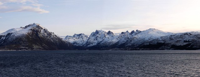
This photo a stitch of 4 photos in Lofoten, Norway


Arriving in Tromsø a winter afternoon in January

July 5, 2015

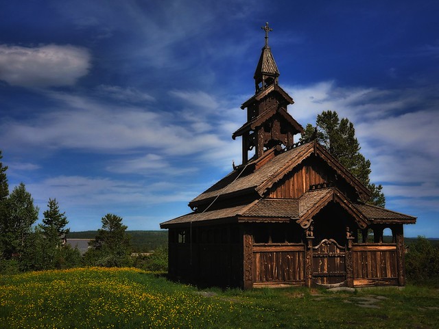
The little StaveChurch in the mountains. Golsfjellet, Norway

The little StaveChurch in the mountains. Golsfjellet, Norway

Scaling is difficult. The small StaveChurch here is like a doll house as it can anly have some 15 visitors to be filled up.

The small copy of the StaveChurch was build to a nearby hotel owners daughter -  just4fun some years ago.

Today from time to time also used for small weddings.

Situated close to the Oset Hotel at Golsfjellet, Norway.


Some "ghosts" in the small mountain chapel